Hydraulic modeling delivers a lasting solution to SSOs in Sanford
 “Sanitary sewer overflow” (SSO) is a polite term for an unpleasant reality, when a sanitary sewer system discharges untreated wastewater into the environment. In Sanford, North Carolina, these overflows occurred during rain events when shallow manholes located within the City’s Dry Creek sanitary sewer basin exceeded capacity, prompting resident complaints and raising recurring public health concerns. While the symptoms were visible on the surface, the underlying causes were not.
Recognizing that effective mitigation would require more than localized fixes, Sanford Executive Director of Utilities Paul Weeks, PE, engaged WithersRavenel to determine why the system was failing. He also needed to discover where corrective investments would have the greatest impact. Through a comprehensive data‑driven investigation, culminating in development of a fully calibrated basin-wide hydraulic model, WithersRavenel helped the City identify the true source of the problem. As a result, they built a road map for long‑term, fundable solutions.
GIS data review reveals gaps in sanitary sewer system asset data
Before diving into any problem-solving, the WithersRavenel team wanted to understand the state of the City’s sanitary sewer system. The City has maintained a growing sewer GIS database since 2012. This involved consolidating information from manhole surveys, CCTV inspections, and more than 10,000 paper as‑built documents.

While this represented a strong starting point, the accuracy and completeness of the data had to be verified before it could support systemwide hydraulic modeling and capital planning decisions.
An initial data gap analysis revealed potential inconsistencies that could undermine model results, particularly at the manhole level. Approximately 350 manholes required validation of key attributes, including the following:
- Pipe diameter
- Pipe material
- Rim elevation
- Invert elevation
- Flow direction
- Structure type
- Condition
To fill these gaps, WithersRavenel deployed field crews equipped with GPS surveying equipment and a 360-degree panoramic camera to confirm physical characteristics and capture visual documentation that the City could be embed in its existing sanitary sewer GIS database.
By reconciling field‑verified information with the City’s GIS records, the WithersRavenel team established a dependable baseline dataset. This step could support accurate model calibration and credible analysis. Therefore, subsequent findings, and the funding decisions they would inform, were grounded in a clear, defensible understanding of the system as it exists.
Smoke testing points to location of sanitary sewer system deficiencies
With a reliable GIS foundation in place, WithersRavenel shifted the investigation from verifying what assets existed to understanding how those assets were performing. While manhole surveys could confirm surface‑level attributes, the condition of the buried pipe network and its susceptibility to groundwater infiltration and extreme inflow during even minor rain events remained largely unknown.
To locate potential sources of infiltration, WithersRavenel conducted smoke testing on approximately 130,000 LF of sanitary sewer and 563 manholes. Completed by a two‑person crew over eight days, the effort allowed the team to quickly flag areas where smoke escaped through unexpected locations. These escapes indicated defects or cross‑connections that could contribute to excessive wet‑weather flows. Because smoke seeping out of manholes and storm drains can cause alarm, WithersRavenel supported the City with advance public notices in English and Spanish explaining the purpose and safety of the work.
The smoke testing effort identified numerous pipe and service defects, as well as 68 cross connections and 125 defective cleanouts.
CCTV confirms condition of sanitary sewer infrastructure
While smoke testing identified where problems were likely occurring, it could not determine what those problems were. Based on the results, WithersRavenel recommended targeted CCTV inspections of approximately 80,000 linear feet of pipe to confirm pipe condition and characterize specific defects. CCTV imaging revealed detailed information about pipe integrity, joint condition, and structural issues. These insights were critical for distinguishing between isolated maintenance needs and systemwide contributors to SSO risk.
Poor structural conditions, including collapses, severe defects, and obstructions, prevented CCTV equipment from safely traversing some pipe segments. In addition, access limitations such as stuck or inaccessible manhole covers further restricted inspection of certain areas.


WithersRavenel and City staff reviewed any CCTV inspections resulting in less than 100% completion, documented them in a Miscellaneous Survey Abandoned (MSA) report, and prioritized them for action via dig and replace.
Flow monitoring data records the sanitary system in use in dry and wet conditions
Together, smoke testing and CCTV transformed the City’s understanding of the Dry Creek basin collection system from a static inventory into a condition‑informed dataset. This revealed how buried assets were actually performing rather than how they were assumed to perform.
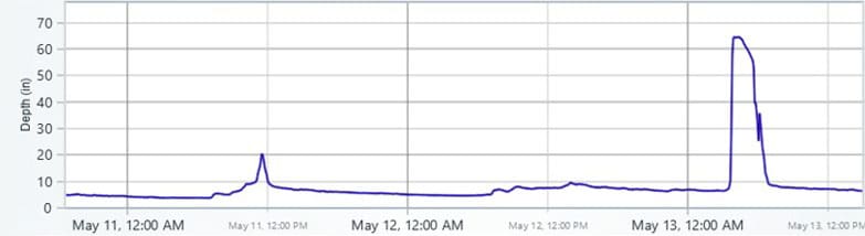
In parallel with the targeted CCTV inspections, WithersRavenel installed temporary flow monitoring devices throughout the basin to continuously record depths, velocities, and rainfall during both dry‑ and wet‑weather conditions. Collecting observed system performance data at the same time that pipe condition was being verified optimized project schedule. It also ensured that subsequent flow monitoring and hydraulic modeling were grounded not only in accurate geometry and documented defects, but in a realistic, data‑driven representation of how the collection system behaves, particularly under wet‑weather conditions.
WithersRavenel used three kinds of flow monitoring devices strategically placed throughout the Dry Creek basin to capture representative system behavior and isolate key contributors to wet‑weather flow:
- Five flow meters recorded flow velocity and depth
- Four level sensors tracked changes in flow depth at critical locations
- One rain gauge recorded precipitation in inches to correlate rainfall with system response
These devices continuously recorded data during both dry‑ and wet‑weather conditions and transmitted to the cloud‑based PRISM platform, allowing the WithersRavenel project team to review and validate system performance data in near-real time while field investigations and CCTV inspections were still underway.

After three months, the monitoring network had captured multiple storm responses, including at least one rainfall event exceeding two inches, providing a robust dataset to support model calibration and confident evaluation of SSO risk.
Updated hydraulic model uncovers surprising source of SSOs
WithersRavenel collated all the data from the manhole surveys, smoke testing, targeted CCTV imaging, and flow monitoring devices to calibrate a basin-wide hydraulic model grounded in observed system performance. Using the calibrated model, the project team simulated a range of operating scenarios for the study area including:
- Dry weather conditions
- 2-year design storm
- 5-year design storm
- 10-year design storm
- 20-year design storm
- 50-year design storm
- 100-year event surface flooding
For each scenario, modelers assessed:
- Peak system capacity?
- Proportion of flow attributable to wastewater versus inflow and infiltration?
- Frequency, location, and severity of SSOs?
Based on resident concerns and historic SSO reporting, City staff initially expected the model to confirm deficiencies near the overflowing manholes themselves. Instead, the analysis revealed that the true source of the SSOs originated upstream. System constraints and wet‑weather inflows combined there to overwhelm downstream infrastructure.
Without this basin‑wide, data‑driven insight, the City might have focused on localized pipe upgrades near the SSO locations. These investments could have temporarily reduced overflows under certain conditions. However, they would not have significantly reduced their overall recurrence. The updated hydraulic model allowed Sanford decision makers to move beyond short‑term fixes to targeted solutions that addressed the root cause of the SSOs.
First-of-its-kind funding application secures money for permanent SSO fix
Armed with clear, data‑driven insight into the root cause of Sanford’s SSOs, the City was poised to pursue a permanent solution but faced an immediate challenge: how to fund the necessary improvements. TriRiver Water, the regional water utility serving Sanford, collects a monthly sanitary sewer fee to support system operations and maintenance. The scale of investment required to address the SSOs, however, exceeded what had been anticipated in existing capital plans. Delaying the project to accumulate funds would have allowed overflows to continue and potentially worsen.
To move forward without delay, the City turned to WithersRavenel’s funding specialists for alternatives. Based on the strength of the hydraulic modeling results and the clearly documented public health and environmental risks, WithersRavenel recommended pursuing a combination grant and loan through the North Carolina Division of Water Infrastructure’s Clean Water State Revolving Fund Program. The application succeeded by using data‑driven modeling to show that targeted rehabilitation upstream, rather than fixes at visible overflow points, would deliver the greatest long‑term reduction in SSOs.
In July, the State Water Infrastructure Authority announced an intent to award Sanford and TriRiver Water $7,292,700, including $3 million in principal forgiveness loans, for Phase 1 construction.
The future of Dry Creek Sanitary Sewer Basin
Design and permitting for the first phase of Sanford’s SSO mitigation begins this spring. Construction should follow in about 18 months, with the goal of completing the project by the end of 2028.
In parallel, the City plans to team with WithersRavenel to pursue a second funding application to support additional, targeted improvements in both the upper and lower reaches of the Dry Creek basin. The City will build on the data‑driven insights from the hydraulic model to further reduce long‑term SSO risk.
The bottom line
By basing each decision on field-verified data and systemwide hydraulic modeling, Sanford moved beyond short-term fixes. They invested in solutions that address the real cause of recurring SSOs. The project provided a clear, defensible path forward for rehabilitation and funding. It also gave City leaders confidence that each dollar invested would deliver lasting reductions in overflow risk. Thus, it would protect public health and improve system resilience for years to come.