From Emergency to Recovery
In the days after Helene, Western North Carolina (WNC) faced a daunting reality: the rain had stopped, but the work was only beginning. Drinking water systems needed to be restored. Damaged roads had to be assessed, and communication lines reconnected. All this while families were still navigating the storm’s immediate aftermath.
For WithersRavenel’s teams on the ground, the response was about more than technical expertise. It was about partnership, coordination, and urgency. By working together with local governments, utilities, and residents, engineering professionals across surveying, funding, GIS, and project management disciplines helped stabilize critical systems. Out-of-area staff also played a vital role. They stepped in to support workloads and provide relief while local staff managed their own recovery at home.
The scale of the challenge was immense. According to the North Carolina Department of Environmental Quality (DEQ), nearly 180 public drinking water systems and 100 wastewater treatment plants across WNC were closed or damaged in early October. Another 40 systems were under boil water advisories. DEQ staff also worked with the Environmental Protection Agency (EPA) to sample bacteria from more than 1,500 private wells in Buncombe and Watauga counties. This highlighted the widespread threat to safe drinking water.
Among the most pressing of these challenges were the situations pertaining to the Woodfin Reservoir Dam and in Chimney Rock, where infrastructure was completely wiped away.
Assessing Damage: Woodfin Reservoir Dam
In Buncombe County, another critical piece of infrastructure, the Woodfin Reservoir Dam, faced severe stress during the storm. Classified as a high-hazard dam by the North Carolina Dam Safety inventory, it is owned and operated by the Woodfin Sanitary Water & Sewer District.
During Helene, heavy rainfall and runoff caused damage to the dam and its access road. This prompted an immediate inspection and damage assessment. WithersRavenel’s stormwater team assisted the District. They conducted a detailed inspection that documented impacts to the embankment, emergency spillway, and other dam components. Their findings provided a foundation for prioritizing emergency stabilization efforts and long-term repair planning.
Reflecting on those early days, Woodfin Water District Executive Director Seth Eckard described the response as an all-hands effort:
“In the days immediately following Helene, our staff worked around the clock to stabilize critical infrastructure, assess damages, and restore service as quickly as possible. We relied heavily on our partnerships with engineering teams from WithersRavenel, local contractors, and emergency management agencies to prioritize repairs and begin the long recovery process. Despite the challenges, our small team demonstrated extraordinary commitment and adaptability under pressure.” – Seth Eckard, Woodfin Water District Executive Director
Progress, one year later
That collaboration proved essential in restoring essential water services to thousands of residents in the Woodfin area. Eckard noted that one year later, the experience has shaped how the District approaches preparedness and long-term planning:
“A year later, the biggest lesson we’ve learned is the importance of resilience, both in our infrastructure and in our people. The storm revealed vulnerabilities but also highlighted the strength of our partnerships. We’ve since begun implementing long-term improvements to ensure that our water system can better withstand future extreme weather events.”
The Woodfin Reservoir Dam inspection serves as a testament not only to technical expertise but also to the shared resilience that defines WNC’s recovery story.
Rapid Infrastructure Assessments
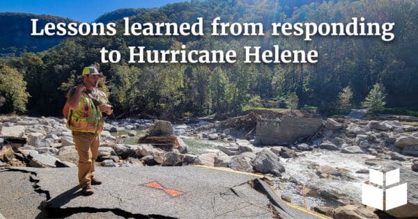
Even as utilities were being restored, safe transportation routes remained a critical need. In areas like Chimney Rock and Bat Cave, sections of NC-9 and US-64 were completely gone. Over a mile of roadway washed away.
WithersRavenel’s Surveying and Geomatics teams deployed immediately, using drone-based orthomosaic imagery and LiDAR to map more than four miles of affected corridors. These rapid assessments gave NCDOT and partner engineers the data needed to design temporary fixes and long-term realignments.