
Written By:


Communities do not need perfect utility records to begin planning for growth. They need a practical way to turn the information they have into a clearer, defensible roadmap for infrastructure decisions.
Growth Is Raising the Stakes Across the Southeast
Population growth continues to reshape North Carolina, South Carolina, and Georgia. According to the U.S. Census Bureau’s Vintage 2025 population estimates, the three states collectively added more than 324,000 residents between July 2024 and July 2025. North Carolina added 145,907 residents, Georgia added 98,540, and South Carolina added 79,958 while recording the nation’s fastest state growth rate at 1.5%.
For local governments, that growth can increase demands on water, wastewater, stormwater, roads, facilities and parks, and other public assets, often while communities are also managing aging infrastructure and limited funding.
That raises a practical question: How clearly can leaders see the systems supporting that growth?
Growth readiness starts with knowing what assets a community owns, where they are, how they connect, when they were installed, and, when possible, what condition they are in. Utility data is the foundation for building that understanding and supporting effective local government infrastructure planning.
You Cannot Plan What You Cannot See
Utility information does not always exist in one complete, current source. It may be spread across GIS databases, record drawings, work-order systems, spreadsheets, paper maps, engineering studies, and the knowledge of experienced staff.
Some assets may be mapped but lack details such as size, material, installation year, condition, or maintenance history. Others may not be mapped accurately or at all.
That situation is common, and it should not prevent a community from beginning.

One message we often share with clients is progress over perfection. Infrastructure planning can stall when teams feel they must reconcile every record, confirm every asset, or resolve every assumption before moving forward. In reality, even an incomplete dataset can be a valuable starting point, provided assumptions, confidence levels, and decision-critical data gaps are clearly identified.
Communities can use what they know today, make informed assumptions where necessary, and refine those assumptions as better information becomes available. The goal is not to create a perfect database overnight. It is to identify reliable information, understand its confidence level and limitations, recognize the most important gaps, and steadily build a decision-ready view of the system.
A practical utility asset management approach helps move information from scattered records into usable insight. Field verification, surveying, remote sensing, record conversion, staff interviews, and data gap analysis can help determine what is known, what is missing, how reliable the available information is, and where additional effort will provide the greatest value.
Start with the Decisions the Data Must Support
A useful data effort begins with the questions leaders and staff need to answer.
Can a proposed development be served without straining the system? Which assets create the greatest service or financial risk? Where should limited maintenance dollars be directed? What happens if funding increases, remains flat, or is delayed?
Those questions help determine which information should be collected first.
Capacity planning may depend on system connectivity, flow data, pump station performance, and treatment limits. Lifecycle planning may rely more heavily on asset age, installation year, condition, expected useful life, treatment options, and costs.
Prioritization should also consider asset criticality and risk, including both the likelihood of failure and the consequences of failure. Two assets with a similar age or condition may present very different risks depending on their location, function, and importance to the overall system.
The objective is not to collect every possible data point. It is to organize the right information to support better decisions.
A Phased Path to Better Utility Visibility
Communities can build a clearer infrastructure picture through a practical sequence:
- Understand the need. Define the goals, risks, budget constraints, and decisions that need to be addressed.
- Assess the gaps. Review existing information to identify what is usable, what is missing, the confidence and reliability of existing data, and which gaps are most important to the decisions at hand.
- Collect and verify. Gather existing records and institutional knowledge, then use field collection, GPS verification, inspections, surveying, or record conversion to address priority gaps.
- Organize and connect. Integrate information into a consistent GIS or asset database.
- Visualize the system. Use maps, dashboards, reports, and other visuals to communicate conditions, costs, capacity, risks, and planned work.
- Analyze and plan. Use hydraulic and lifecycle models to compare growth, funding, maintenance, and capital strategies.
- Monitor and adjust. Update information and assumptions as projects are completed, assets are inspected, conditions change, and better data becomes available.
A community does not need to assess every system at once. It can begin with one utility, asset class, service area, or priority corridor and expand over time.
Through our broader Infrastructure Asset Management services, WithersRavenel and WR Technologies have helped more than 150 communities across the United States with similar needs, including GIS development, data gap analysis, field data collection, asset inventories, lifecycle modeling, dashboards, and decision-support tools.
That experience allows our team to meet communities where they are, whether they are refining an established program or starting with incomplete records.
What This Looks Like in Practice
Real-world applications show why phased progress matters.
During the Fuquay-Varina comprehensive lifecycle modeling project, our team evaluated pavement, water, sewer, and stormwater GIS databases with different levels of completeness. Each system had enough information to begin modeling, but the strength of the long-term projections varied based on the quality and completeness of the available data.
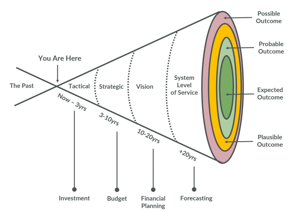
More relevant, accurate, and representative data can narrow uncertainty over time. Incomplete or lower-quality asset data can widen the range of possible long-term outcomes. However, reducing uncertainty is not simply a matter of collecting more information. It depends on the relevance, accuracy, and representativeness of the data, as well as how well the analytical model is calibrated.
For the Town of Cary, a water system innovation project began by evaluating existing hydraulic models, previous studies, and operational data before collecting additional field measurements. The resulting information helped translate complex system conditions into approachable metrics and visuals that could support future investment decisions.
These examples reinforce an important point: Communities can start with the information they have and improve the picture over time.
Better utility data can support hydraulic modeling, lifecycle planning, capital improvement planning, funding strategy, development review, operations, and preventive maintenance.
For capacity decisions, however, data becomes most useful when paired with appropriate analysis and calibrated models. Those models may account for factors such as system demands, connectivity, pump and storage performance, operating conditions, treatment limits, and applicable level-of-service criteria. Together, the data and analysis can help communities evaluate what-if scenarios before growth or asset deterioration creates a more urgent and expensive problem.
Make Information Useful Beyond the Technical Team
Utility data becomes more valuable when it is easy for nontechnical audiences to understand and use.
Maps, dashboards, charts, and other visual tools can help managers, elected officials, finance teams, planners, and economic development leaders quickly see where risks are increasing, how growth may affect the system, and what different investment strategies could accomplish.
Not every person or department needs direct access to the underlying software or dashboard. Technical staff and licensed users can translate findings into screenshots, reports, presentations, and other accessible formats so leadership and departments can work from a shared understanding of infrastructure conditions and priorities.
This shared understanding is especially useful during budget conversations. Lifecycle models and other data-backed tools can help communities demonstrate what existing funding can accomplish, identify the consequences of deferred investment, and provide stronger justification when additional funding is needed to maintain a desired level of service.
Long-serving employees also carry system knowledge that may not appear in formal records. Staff interviews, field verification, and updated records can help preserve that knowledge before staffing transitions or retirements create information gaps.
See Capacity Before It Becomes a Constraint
Growth readiness does not begin with a perfect dataset, a finished model, or a major technology purchase. It begins with a clearer, shared understanding of the infrastructure already in place and the decisions that information needs to support.
By improving utility data in phases, communities can turn uncertainty into a practical roadmap, communicate needs more clearly, stretch available funding further, build data-backed support for future budget needs, and prepare for growth with greater confidence.
The clearer the system becomes, the better positioned a community is to identify, model, and address capacity constraints before they limit growth.
Let’s Connect
Whether your community is improving an existing GIS, assessing gaps in utility data, building an asset inventory, or preparing for hydraulic and lifecycle modeling, WithersRavenel and WR Technologies can help establish a practical approach based on your priorities and available resources.
Connect with our Infrastructure Asset Management team to start turning complex infrastructure data into a clearer, defensible roadmap for growth.


You Might Also Be Interested In....




About the Authors

Lindsay Thomas, GISP
Implementation Team Lead
Lindsay is a longtime project manager, lifecycle planning expert, and certified Geographic Information Systems Professional (GISP). She has been working at WithersRavenel for 19 years; her current focus is on asset management plan implementation, where she takes her knowledge of databases and decision-making processes and combines them into one asset lifecycle model for clients. While working with municipalities, her knowledge of software and services helps inform their decision-making so they can target asset management plans and solutions to address growth, repairs, and rehabilitation.
She has many years of experience in database design, community GIS development, map-making, and implementation.
Pam Austria
Implementation Consultant
Pam helps organizations turn complex technical solutions into successful business outcomes. Drawing on more than a decade of experience managing creative and production workflows in the entertainment industry, she now helps engineering organizations implement lifecycle modeling solutions. Her expertise includes process improvement, change management, stakeholder engagement, onboarding, and driving user adoption.